Introduction
Our regular readers won’t be surprised that it’s here. Neither the fact that we have it and the review is coming. Well we weren’t wasting any time and on our way home from CeBIT we’ve already been using Nav N Go’s latest piece of software for navigation. These 12 short hours were kind of enough for having a first impression and the experience gained since then made let us know mostly everything about it. Let’s not be so hasty and take a look at what were preceding iGO8.
iGO8 has been announced a long time ago, to be more exact we could have seen some background info about our countries most popular navigation software at last year’s CeBIT. We were outmost excited back then and were hoping to take the final product in our hand in April 2007. As it turned out there was a considerable amount of lag (that is one year), but looking at the final version this is no wonder: creating something like this is no easy task.
The history of navigation dates back to ancient time, but satellite-based solutions have only recently replaced the “let’s draw something route-like on the back of an ancient map” method. All right, there have been more sophisticated attempts too, but these can be considered failures compared to results achieved by PNAs (that don’t really cost that much nowadays) combined with maps covering the whole of Europe (having the same modest price-tag). In a word it’s enough to look around in cars sitting in the usual daily traffic jam and we can see a high number of navis sitting on windshields.
Hirdetés
Winds of change
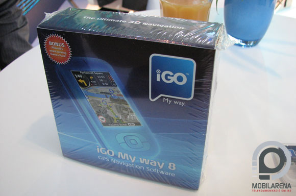
Upon opening the box we were happy to observe that the map included, completely covering Europe, is on a 2GB microSD card and both a miniSD and an SD adapter are supplied, so we can finally install the app on any possible device. The setup process is fast and is almost the same as in previous versions – as there is nothing to change on something that is already good. Unfortunately we are bound to have some unpleasant moments in the first couple of hours of use, but it is clear in the long run, that all changes are logical and well thought out, even though getting used to them is not effortless. Let’s begin with some customization: there is an advanced and a simple mode; the latter one being much better for learning the use of the software, this is when only the most necessary options are shown, thus avoiding confusion. The background is changeable, so we can keep looking at some lovely hearts if we would like to.

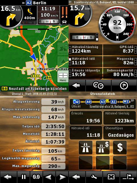
The whole user interface has been redesigned in a considerable manner. The whole thing has a new, much more modern look, it is now clear that besides functionality, the so-called “user experience” is also emphasized, as it is fashionable. Let’s begin with the main menu: the buttons in a circle are now gone and they are replaced by four huge icons (more like wall-paintings based on their size). The globe in the lower corner shows the map and we have a main switch too. The four icons are used for creating a new route, modifying one and opening up the options menu. Mostly icons are used to symbolize functions, which can be a real advantage compared to the “old” text menu, but sometimes the icons’ functions are only revealed only after clicking on them. There is a new kind of route-planner: besides the usual fastest, shortest and cheapest modes we now also have a “traceable” mode, in which the program tries to plan the least amount of twists and turns into the route, so I’d rather call this “blonde” mode, thus making target users find it easier…

There are lots of changes. There is band tracking at last, which is visible on-screen when we are driving on a road with many bands headed in different directions; “good” lanes are marked with yellow, others with white. Besides this the software doesn’t warn us, so taking a look at the screen is advised in some situations. It is another new feature that we can place a compass on top of the screen, but something even better is that we can not only see the next maneuver, but the one after that too, so we can prepare for more complicated turns. On our way from one place to another we might want to stop for refueling for example. This can be simply done by clicking the “detour” icon (always displayed); furthermore the software selects from nearby POIs, so we have to make the shortest detour to get to an ATM for example. There is the possibility of searching for POIs around the cursor or around the target, so we fully utilize the database. This is an element that has undergone huge development, there are tons of data at our disposal.

3D, the big hit
Yes, YES! The world has ceased to be a 2 dimensional place, iGO 8 is not only a spaghetti of stripes running around, but a world easily recognizable by us, showing buildings, or at least contours of them, we can see by looking out of the car. Of course not always and not everywhere. When in downtown, passing trough narrow streets, buildings get faint – just like Melvin in Jeff Dunham’s show, even though he looks at boobs with his X-ray vision instead of buildings. Of course the picture is far from being completely realistic, but it’s more than enough to make locations recognizable.
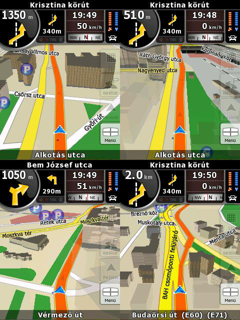
Not only houses are displayed, but any object that is large enough to be characteristic of a given place. Even more, flyovers have a shadow, but if this is still not enough: iGO8 switches to night mode when passing through a tunnel, thus avoiding the light of the navi blinding us. Of course it doesn’t do it with light sensors. It knows where tunnels are. It’s simple but effective and shows very well that the designers have thought of small details too.
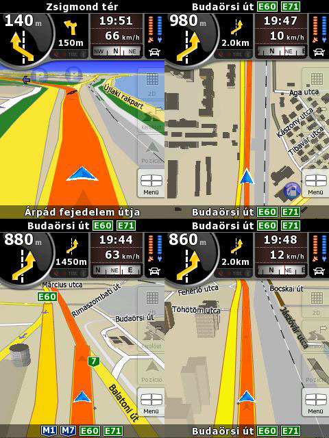
Buildings are present everywhere where there is some kind of sizable civilization and they get more and more detailed as we are closing up to a city center. Unfortunately, contrary to the gossip, the software won’t read out street names, this might be available in the next version. Of course the map has relief data too, besides the standard view from above and 3D, just like in the world atlas. iGO8 is “ONS-compatible”. It can collect, organize and display such an amount of data of our trip, that no experienced statistician will ever take a look at the yearbook again if he can take a hold of such an application. It measures our speed, average speed, greatest speed, travel time, standing time, lowest and highest position and of course distance too. Shocking, isn’t it?
Summary
The program has changed completely; there are no parts that haven’t been revised by the designers. And this has been done by keeping simplicity and usability as a primary goal. If we are newcomers in the world of navigation than we are bound to succeed – if changing from a previous version than some minor difficulties might occur while getting used to the new interface.

In spite of its complexity, the program fits onto a 2GB memory card and there are no problems with its speed. We have been intentionally using an HTC Kaiser for testing, as that is known to have some display problems. Kaiser snapped its fingers at all this and ran the application without any problem. So those who had any restraints regarding the hardware requirements of the software can now rest assured.

iGO8 is much more advanced from all points of view; I think that it currently supersedes every application on the market and it has 3D too. Based on what we know today there is nothing much left to improve, so people at Nav N Go have a lot to think about regarding the next major improvement. It’s sure that there are more ideas to come as upon asking “what else can come after this?” the CMO of the company has only responded with a mysterious smile.

According to officials iGO8 is to hit the market in a month, but we have no information about its price and upgrade possibilities. Based on recent news I dare to say that Mio committed a major error when teaming up with Navman. As for me I can only put a huge “Highly recommended” award, hoping that iGO8’s price won’t be a drastic one.
 |
| iGO 8 |
Gubro
Translated by Szaszati
iGO has been provided by Nav N Go.
On-line at www.igo.hu.


