What is this?
„Have you heard of it?
Of course.
And?
It’s expensive.”
This is how would Priszi characterize the discussion that’s going on nowadays between him and his acquaintances when they are talking about this metallic monster. We have again received a device for testing (yes, thanks to SpeedShop), which we, editors somewhat familiar with mobile phone topics, didn’t have much to do with. So we have found a professional who had the device for 10 days and then he sent his experiences and observations to us.

He, however, is a professional. Blam, he started the article right in the middle, but it won’t hurt if we describe the target users of Colorado. This is a navi, something like those in our cars, but Garmin designed it for a different task. Its heavy-duty design, it’s (hopefully) long operation time, its size and additional features make it an alternative for those who hike, who are looking for geocaches in the wild, climb rocks and peek at birds in dawn. Knowing this, let’s return to the discussion quoted before and from now on the word goes to Priszi:

It’s expensive? Of course I immediately get told that all others have started with a similar price, why do I expect this one to be different. Well maybe because there might be devices with a specific goal, designed with some compromises in mind, have a better price/value ratio. Previous models are still available and currently they have a better price. It’s very important to have a clear idea about what do we want to use it for! That’s because if car navigation is a goal, then there are other alternatives, as this navi wasn’t designed for that! I know it can do it, but it’s still not designed for it. It won’t talk, only beep, the route cannot be defined so precisely as on other navis, and those cost (with full maps) half as much as Colorado.

This, however, has extras like barometer-based height measurement, electronic compass, heart- and pedal rev meter and it’s even water-resistant. So it is made for hikers. For those who actively participate in technical sports (and I mean actively with capital letters, as this navi is too expensive for getting a couple of geocaches). They, however, are amazed by a nice display for as long as a 2000 mAh battery would keep this device online.
Hirdetés
Exterior
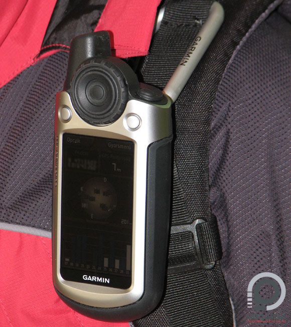
I liked its design. The rotating console can be taken apart for cleaning. I think those will really need to do regular cleanings who intend to use it in dusty places. There are no physical switches in the dial. Everything is under the blue rubber, locked away in a water-resistant place. The grip sensor isn’t mechanical either; I think it has a magnetic sensor which observes the position of the small piece of metal inside the dial, which is a really cool idea, as it is truly water-resistant this way.

I didn’t like the case that much. There is such a large gap between the metal front cover and the plastic back that I seriously doubt that this could hold water back. My doubts didn’t go away even after taking off the back and having a look at the insulation of the battery and the memory card. As I wasn’t authorize to perform a stress test I have to say that I believe it is water resistant only after I see it for myself.

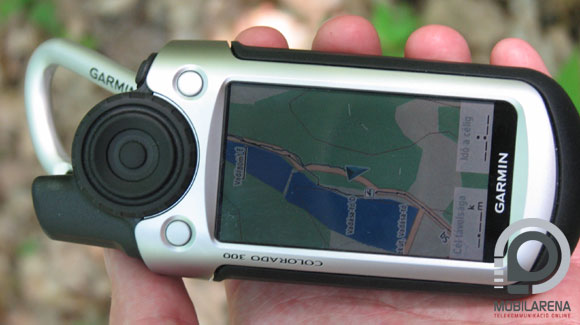
The display is amazing; the more the sun shines, the more amazing it gets. I can only dream of such a display for my PDA that would be readable in sunlight! Resolution also supersedes previous models, as picture quality is fascinating at 240 x 400 pixels. Backlight is not that superb, it won’t be good as a flashlight, but at least it won’t be a stress for the eye in darkness. The name Garmin is a warranty for the display anyway; these are the ones that provide the best picture in car navigation systems too.

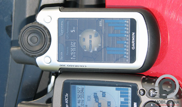
I won’t praise the GPS receiver’s sensitivity. It’s not better, nor worse than the one in the previous model. I have tested it on the edge of a forest and it saw 10 satellites and located with 5 meter precision, just like 60CSX or Vista HCX (I also had these with me).
Experiences
I had it for three weeks, but it had a failure on the very first day, and I think I will have to live with this experience forever. My first impression was that I couldn’t turn it on. Then it turned on all by itself, but it had the same problem at next start. Theoretically the power button has to be depressed for a short time, but it didn’t really do the same thing at two pressures of the same length.

I have been in a darker place then, so I tried turning on backlight. I turned the dial, I was at maximum level, but I still can’t see a thing. Is this all that it knows? Of course not. This is a feature! If the battery is running low, it won’t let you waste resources, so it decreases backlight strength. After some reading I learned that this can be turned off, but not on all software versions. There is a patch that lets the user override the automatics.

I’ve just been through the first impression, but then came the next shock: the battery went flat. But why? I knew that this was impossible, but I still replaced it. It didn’t even turn on with the next set. Oh my God. Luckily I had what to choose from. I don’t want to write too much about the case, but it’s good to know that it had problems with battery management both with software version 2.3 and 2.4. It’s already known that with software version 2.3 we had to set the device to battery mode even if were using accumulators, in order to make them judge remaining power correctly. I have experienced with both software versions that when I chose alkali as battery type instead of NiMH, the navi kept running for hours with a set of batteries it considered as dead before.
Unfortunately this wasn’t the only problem I had. I knew that there is a software update so of course I thought it would be a good idea to install it. But I didn’t succeed at first. I went to the manufacturer’s homepage, downloaded an online software updater, installed it, and then the navi went offline and I couldn’t turn it on after the update. I saw the Garmin logo so I’ve thought that it’s slow, but not: the little bastard didn’t go any further in the startup process. ”My dear, I’m going to pay!” Another attempt and fortunately with some more success now. Okay, I won’t have to pay it. Let’s see if it did any good with the menu. Well, well…? Of course it didn’t.
Menu
The menu looks like a roundabout. We can get anywhere by rotating and clicking. This is something I can take. But further submenus of the main menu are quite plain. Maybe the designers have thought that it would be better not to let the dumb user tamper with all the settings, as he will just do something bad. And so they’ve put all fine-tune settings in the main menu’s “Settings” submenu. But that’s not it! There’s no way to set the position of North (up or down) during navigation (even iGO knows this, although it’s unnecessary there). We shouldn’t switch between bee-line and road-based planning, as we’ll get dizzy, it needs so much twists and turns. All fine things are under the settings and other menus, all other menus have a minimal number of submenus and not in the most logic distribution. We fortunately have the option of setting things in the main menu, as an extra we can even set up profiles. This way we only need about one afternoon to configure everything to our liking. It’s worth making a backup save of these settings, as we can do it, since we might have to use it sometime, just like I had to.

As for the languages… There are translations, but they are unusable. If we have the possibility we should be using the navi in English, or we might download the free translation of some gadget-fanatic guys.

The navi comes with a lot of memory, and a very sympathetic feature: SD card support. SD like real SD, not mini or micro. The card that is the cheapest and simplest to obtain. I like this very much. But I didn’t like that it didn’t always recognize the inserted card. Taking it out and putting it back again helps. I tried using a highly detailed map, observing if it handles it faster than other navis. It is a bit faster, but we still have to wait a bit, when moving large amounts on a map portion with many details.
Other, summary
The list of accessories includes a data cable, which is a standard USB-miniUSB. We shouldn’t just pull this out from Colorado when we’re done using it, as it just simply hangs up. I managed to meet this “feature” twice. Instead you should click on “Safely remove hardware” in Windows, and then we can pull it off.
The thing that I didn’t understand, that if it has so much memory (384 MB), why is there a limit for geocaches and waypoints? In turn we can upload these not only as coordinates but with full details. This way we don’t only have the coordinates of a point, but we can download a description of every point. The format used is .gpx; the geocaching site uses this format for descriptions, so we don’t even have to print them, just copy them on the navi and hope that the battery won’t go flat.

I have been experimenting with free maps; openmaps.eu proved to be a fine source, the navi supported all of the maps. It even planned routes on them. Of course there are tons of maps for money, but the cost of maps will be an extra cost added to the navi’s price, which is already quite expensive. In turn we get updates and coverage for many countries.

And a short summary. Colorado currently costs about 483 EUR at Speedshop, while the good old 60CSX costs only 380 EUR and I didn’t even mention eTrex Vista HCx. (We will, however, review this one too, in detail).

For this price we get a bigger and better display, a metal case, internal memory, wireless data transfer and support for viewing pictures. Still, we have some downsides too: even more complicated menu, slow booting, less buttons, less operating time and unstable software (although I have to mention that this manufacturer usually updates the software and that can be downloaded).
Prisznyák Gábor
The sample device has been provided by www.speedshop.hu, thanks. To access the shop please click here.


